Da Lat is a different sort of Vietnamese cycling destination. The city sits around 1,500 metres above sea level in the Central Highlands, where pine-covered ridges, vegetable farms and long descents replace the heat and flat roads many visitors associate with the country. There is enough climbing for a demanding road trip, but also quieter lanes and off-road riding if you know where to look.
The difficulty is choosing roads that work on a bicycle rather than simply following a sightseeing itinerary. Main approaches carry buses and lorries, weather can turn quickly and a route that looks short on a map can involve repeated steep ramps. This guide focuses on useful riding areas, sensible ways to connect them and the practical decisions that make a few days in Da Lat worthwhile.
Why Da Lat is worth a cycling trip
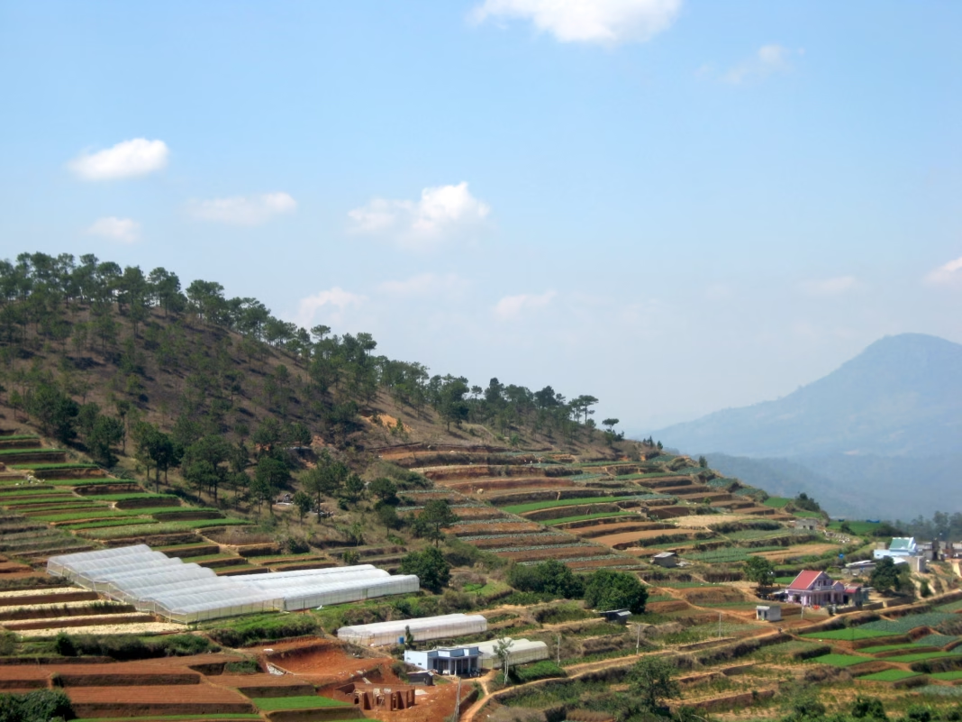
Da Lat’s strongest asset is variety within a relatively small area. Ride out of the centre and you can be beside a lake, in a pine forest or passing working farms before you have settled into a rhythm. Coffee-growing hills, tea plantations and valleys create routes that feel quite different from one another, even when they begin at the same hotel.
Altitude changes the experience, too. The air is usually cooler than in Ho Chi Minh City, so a sustained climb can be more comfortable than it would be at sea level in southern Vietnam. That does not mean every day is easy. The city itself is hilly, the roads rarely stay flat for long and the combination of altitude, heat when the sun comes out and repeated changes of gradient can catch out riders who start too hard.
It is best approached as a riding base rather than a single famous climb to tick off. Da Lat does not have the established cycling infrastructure of the Alps or Girona. Its appeal is a network of contrasting roads, stops for coffee and food, and the opportunity to explore a part of Vietnam that many international visitors see only from a tour bus.
Choose your bike and where to stay
A road bike with low gearing and room for wider tyres is the most flexible choice for the main paved routes. A compact chainset or similarly easy climbing gear is useful when a road rises sharply without warning. If you have a gravel bike, its extra tyre clearance is a benefit on rough shoulders and minor farm roads, although it does not turn every unpaved track into a suitable cycling route.
For a first visit, staying within reach of Xuan Huong Lake makes logistics easier. There are cafés, restaurants and shops nearby, and several rides can begin from the city without a vehicle transfer. The trade-off is traffic around the centre, particularly at weekends. A quieter base near Tuyen Lam Lake gives easier access to wooded roads but can mean a longer trip into town for meals or bike repairs.
Arrange bike hire or a guided ride before travelling rather than assuming a suitable performance road bike will be available on arrival. Ask for the exact model, size, gearing, brake type and tyre condition. If bringing your own bike, confirm whether your accommodation has secure storage and whether an airport transfer can take a bike box.
Four riding areas to build a trip around
Xuan Huong Lake and the central hills. The roads around the lake provide an obvious orientation ride. Local government information describes a roughly five-kilometre circuit, but it is not a closed cycle track and traffic conditions change through the day. Use it to work out road layouts and test your bike, then add nearby streets only where you are comfortable with junctions and scooters.
The lake works particularly well on the first morning or as an easy spin after travelling. Do not mistake the short circuit for a guarantee of flat riding: almost any route away from the water begins to climb. Early daylight is preferable to a busy evening lap, and stopping at junctions is more important than maintaining an uninterrupted training effort.
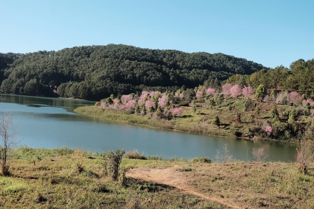
Tuyen Lam Lake and the southern pine roads. South of the city, Tuyen Lam Lake sits among wooded slopes and is one of the more attractive directions for a scenic ride. The route out and back can be kept manageable, or extended through neighbouring roads if a current map and local advice confirm that they are suitable for bicycles. Expect changing gradients rather than one steady alpine ascent.
Some roads around the lake serve resorts, tourist attractions and residential areas, so quiet scenery does not always mean light traffic. Allow time for photographs and a café stop, but avoid following a navigation app down an unverified lakeside path. There are private entrances and tracks that may not be rideable on a road bike.
Trai Mat and the Cau Dat tea hills. Heading east takes you towards Trai Mat, the Linh Phuoc Pagoda and the tea-growing country around Cau Dat. Cau Dat is roughly 25 kilometres from central Da Lat by commonly used road approaches, making the out-and-back a substantial ride once the climbing is included. The old railway corridor is a useful landmark, but it is not a continuous traffic-free cycleway.
The attraction here is the changing landscape. Urban streets give way to smaller settlements, agricultural slopes and higher, more exposed tea country. Check the chosen roads before setting off: the scenic road itinerary used by motorcyclists is not automatically the safest road-cycling itinerary. Returning by the same route can be preferable to completing a loop that requires a busy main road.
Ta Nung and the western valleys. West of Da Lat, roads towards Ta Nung pass coffee-growing land and a succession of valleys. This is a good option for riders who want a longer day with repeated climbs and descents rather than a single summit. Start with an out-and-back and turn around when the road, traffic or weather stops being enjoyable.
There are tourist sites and viewpoints along the way, but treat them as optional stops rather than points you must reach. The surface and traffic mix can change quickly near junctions and attractions. Build the route around the quality of the riding, not around collecting every waterfall or café pinned on a map.
Climbing, descending and sharing the road
The approach towards Lang Biang, north of Da Lat, gives another way to experience the highlands. The mountain is a well-known walking and sightseeing destination, with roads and tracks serving the surrounding area. Riding towards its foothills is different from assuming that every road inside the tourist area is open to cyclists. Check access locally before treating a summit or park entrance as a route objective.
The hardest parts of a Da Lat ride are often short rather than spectacular. A steep ramp after a junction, a sharp turn on a descent or a climb beginning immediately after a stop can be more awkward than a long, regular gradient. Choose gearing that lets you keep turning the pedals when tired, and leave something in reserve for the final kilometres back to the city.
Traffic drives on the right in Vietnam. Expect motorbikes to appear at junctions, vehicles to stop without much warning and buses to need more space than a cyclist might anticipate. On narrower roads, ride predictably, avoid sitting in a driver’s blind spot and do not force a pass simply to hold your speed. A local guide can be especially valuable on the first day.
Descending needs as much attention as climbing. Heavy rain can wash grit and soil across corners, and damp patches may remain under trees after the open road has dried. Brake before the bend, keep a margin from the road edge and be prepared to shorten a ride rather than descend unfamiliar mountain roads in darkness or thick mist.
Gravel and mountain biking in the highlands
Da Lat also has a reputation for mountain biking. Pine forest, hillside tracks and agricultural land provide a different experience from the paved roads, and Vietnam’s national tourism authority highlights mountain biking among the area’s outdoor activities. That is a reason to consider a guided off-road day, not a reason to assume every forest track is publicly accessible.
For a gravel ride, ask a local operator to distinguish firm farm roads from trails that become muddy or impassable after rain. There may be steep, rutted sections that are enjoyable on a mountain bike but frustrating on narrow tyres. Some routes cross working land, so permission and respectful behaviour matter as much as fitness.
A mixed itinerary can work well: two days on the road, followed by an off-road ride with a guide who knows current trail access and conditions. This also avoids relying on an online GPS trace that might be several years old. Save an offline map, but use it as a navigation aid rather than proof that a track remains open.
Weather: when to ride and what to pack
December to March is generally the most reliable window for a cycling-focused visit. The highland climate is comparatively cool and dry, although early mornings can still be chilly. From roughly May to October, rain becomes a much bigger factor, often building later in the day. November and April are transitional months rather than guaranteed dry-weather alternatives.
Start early, especially during the wetter months. A clear morning does not rule out heavy afternoon rain, and exposed roads can become unpleasant quickly when the wind rises. Check the forecast for the areas you plan to cross, not just the temperature shown for central Da Lat. Fog can reduce visibility even when the rain has stopped.
Pack a lightweight waterproof, a warm layer for descents and lights that are visible in mist. Carry enough water between settlements, but also plan stops where you can refill safely. A puncture kit, pump, spare tube or tubeless repair supplies and a charged phone are more useful than chasing an exact average speed. If there has been prolonged heavy rain, ask locally about landslips and road closures before riding a pass.
Da Lat is popular with domestic visitors. Weekends and national holidays can make both the city and the roads to attractions busier. A midweek base and early departures give you more freedom to choose a sensible line on the road and to stop without competing with crowds.
A practical three-day cycling itinerary
Day one: settle in and ride south. Check the bike, ride a short circuit near Xuan Huong Lake and continue towards Tuyen Lam if conditions are good. Keep the first outing deliberately flexible. The point is to learn how traffic behaves, how quickly the road climbs and how long it takes to leave the centre, not to set a distance record.
Day two: the eastern tea country. Make Trai Mat and Cau Dat the main objective. Set off early, carry a little food and allow time for stops in the villages. An out-and-back lets you judge the return journey and avoids committing to an unfamiliar main-road loop. Shorten the ride if cloud or rain develops over the higher ground.
Day three: western valleys or an off-road guide. Choose Ta Nung for another road day, or book a guided mountain-bike ride if you want a different view of the landscape. Riders with more time can add a fourth day towards the Lang Biang foothills. Keep the final ride modest if you have a transfer or a long flight ahead.
Do not treat these as fixed GPX routes. Exact distances and elevation gain depend on your accommodation, road choices and access restrictions, and a mapped road may not be pleasant or safe for cycling. Before each ride, compare a current map with advice from a local rider or reputable operator.
Practical travel advice for UK cyclists
Lien Khuong Airport is around 30 kilometres south of Da Lat, with onward road transfers into the city. International visitors often connect through a larger Vietnamese airport, although airline schedules and baggage rules can change. Check bike-box acceptance and any extra charges before buying tickets. If arriving by bus, confirm that the operator will carry a boxed bicycle rather than assuming there is space.
For British citizens travelling on a full British passport, current UK government advice says tourism visits of up to 45 days can be visa-free, subject to entry conditions. The passport must normally be valid for at least six months after arrival and have two blank pages. Check the latest entry and health-declaration guidance shortly before departure rather than relying on a travel article for border requirements.
Travel insurance should explicitly cover the kind of cycling you intend to do, particularly off-road riding, organised events or remote mountain routes. Carry basic identification and emergency contacts, and have a plan for returning to your accommodation if weather or a mechanical problem ends a ride early. A taxi or pre-arranged driver may be a better option than pressing on with a damaged bike.
Da Lat makes most sense as part of a broader cycling trip when you have several days to adjust to the roads and altitude. For other routes with a very different character, see our Shimanami Kaido cycling guide and our Congo Nile Trail guide. The cycling travel hub brings together further destinations, while our Tatra Mountains guide covers another climbing-focused base.
If there is one choice that will improve a Da Lat trip, it is resisting the temptation to cover too much ground. Choose a small number of roads, leave space for the weather and take time to explore the valleys between the climbs. The riding is better when you are not trying to turn every kilometre into a sightseeing checklist.
-
 Photo Credit: XDS Astana Team (official rider portrait)