Rwanda’s Congo Nile Trail follows the green hills above Lake Kivu, threading between coffee-growing villages, fishing settlements and steep red-earth tracks on the country’s western side. The established route runs for approximately 227km between Rubavu and Rusizi, usually taking around five days by mountain bike. It is one of Rwanda’s best-known adventure cycling routes, with a strong sense of place and plenty of climbing packed into relatively short daily distances.
Lake Kivu is the constant landmark, although this is rarely a level ride beside the water. The trail repeatedly leaves the shoreline to climb through farms and villages, then drops towards another bay. On some stretches there is firm gravel; on others the surface is loose earth or broken stone. A day of 40 or 50 kilometres can involve six hours out on the bike once the gradients, technical descents and stops are accounted for.
Most cyclists arrange a local guide, bike hire and luggage transfer rather than carrying everything themselves. There is also the option of riding individual stages, which can make more sense than attempting the full distance on a fixed five-day schedule. Different operators use slightly different connecting roads and overnight stops, so a quoted distance of 227km should be treated as the standard tourism-route figure rather than an exact measurement for every itinerary.
Important travel advice, October 2026: The traditional route begins near the Democratic Republic of the Congo border and ends in another border district. The UK’s Foreign, Commonwealth and Development Office advises against all but essential travel to parts of Rusizi District within 10km of the DRC border. Australia’s Smartraveller currently advises against travel to Rubavu District, including Gisenyi, because of the risk from conflict across the border. These warnings can affect the established start and finish and some insurance cover. Riders should not book the complete route without first checking current government advice, local security conditions and whether a safe alternative itinerary is feasible.
Where the Congo Nile Trail runs
The route is entirely in Rwanda despite its name. ‘Congo Nile’ refers to the watershed between the river systems that ultimately drain towards the Congo and the Nile. The cycling trail follows the eastern side of Lake Kivu, with views across the water towards the Democratic Republic of the Congo. Along the way, the hills are densely settled and intensively farmed, so cyclists pass homes, markets and working land rather than spending five days in an isolated national park.
The classic north-to-south itinerary starts near Rubavu, also widely known as Gisenyi, and heads towards Kinunu. It continues through the Rutsiro hills to Karongi, often called Kibuye, before tracing the more southerly shoreline towards Nyamasheke and Rusizi. Operators sometimes use Mugonero and Kumbya as overnight stops. Those names are helpful when comparing itineraries, but they do not represent a single fixed sequence of compulsory checkpoints.
The landscape changes within a day’s ride. Coffee and banana plants cover the slopes in the north, small settlements occupy ridges and valleys, and tea-growing areas appear further along the route. Some roads run above wooded bays; others pass terraces that have been cultivated for generations. The lake may disappear behind a rise for an hour and then return as a wide view between two hills.
Rwanda’s tourism authorities describe the full trail as a five-day bicycle ride, but the choice of track can be as important as the day count. Some guided groups combine earth tracks and paved transfers, while more demanding itineraries retain extra off-road sections. Ask an operator for a current GPX file and the actual route for each day, not simply the headline kilometres.
A five-day cycling itinerary along Lake Kivu
One practical way to understand the trail is to break it into five successive riding days. The example below reflects a commercial off-road itinerary that uses Kinunu, Karongi, Mugonero and Kumbya as overnight points. It is a planning illustration, not a claim that the official 227km trail has five universally agreed stage boundaries.
| Day | Illustrative section | Approximate distance |
|---|---|---|
| 1 | Rubavu (Gisenyi) to Kinunu | About 42km |
| 2 | Kinunu to Karongi (Kibuye) | About 60km |
| 3 | Karongi to Mugonero | About 47km |
| 4 | Mugonero to Kumbya | About 45km |
| 5 | Kumbya to Kamembe / Rusizi | About 44km |
Those example days total around 238km, while other operators quote close to 250km and Rwanda’s tourism authority uses 227km. The differences arise from start points, diversions, local trail options and transfers. The sensible comparison is the distance and elevation gain on the particular itinerary you intend to ride, with enough margin for changes caused by weather or road works.
The northern day towards Kinunu introduces the rhythm of the route, moving between the lake and inland villages. A fishing settlement such as Nkora makes a natural place to stop, with boats and daily trading activity along the waterfront. The following ride towards Karongi is often the hardest single day in a five-stage plan, with substantial climbing and few truly flat kilometres. A nominal 60km here should not be mistaken for a straightforward three-hour spin.
 Photo Credit: RebeccaRwanda
Karongi gives riders an opportunity for a proper rest beside the lake. Hotels and guesthouses are more numerous here than in the smaller rural stops, and the town makes a sensible place for a rest day if the trip allows. Riding onwards to Mugonero means more climbing away from the waterfront, followed by a network of smaller roads and paths through settled countryside.
The final two days in this example travel via Kumbya towards the southern end of the lake. They can be comparatively remote, with longer gaps between reliable mechanical assistance and a need to confirm where water and food will be available. The endpoint at Kamembe or Rusizi is particularly important to review against current border-area advice. Depending on that assessment, a supported partial itinerary ending farther north may be the appropriate alternative.
The climbing and surfaces are the real challenge
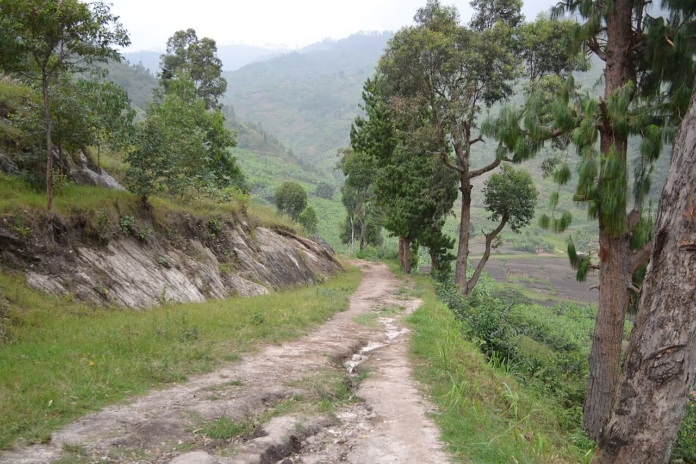
The Congo Nile Trail is better approached as a mountain-bike journey than a road-cycling holiday. Firm dirt and gravel can change to washed-out earth, loose rock or rutted descents, particularly after heavy rain. A mountain bike with low gearing, reliable disc brakes and suitably grippy tyres is the safest straightforward choice for the full off-road route. Experienced gravel riders may manage selected sections, but a narrow-tyred road bike is not appropriate.
A guided five-day itinerary can involve roughly 950 to 1,300 metres of climbing each day, according to published operator figures. Those numbers vary with route changes, and elevation estimates from different mapping services will rarely match exactly. What matters is that the trail climbs often: a short steep ramp can be followed by a quick descent and another ascent long before the lunch stop.
Riding speed is therefore a poor guide to the time required. A competent cyclist might comfortably ride 80km on smooth roads in Britain and still find 45km here tiring. Technical handling, repeated accelerations, heat and stops all increase the time spent on the route. On narrow lanes, leave room for people walking, livestock and local bicycles, and avoid treating the descents as timed segments.
 Photo Credit: François Terrier
The lower sections can also become muddy surprisingly quickly. Deep ruts and slick clay are hazardous even at modest speed, and repairing a puncture in a village without suitable spares can turn a routine mechanical into a long delay. Experienced riders should bring a pump, tyre plugs or tubes appropriate to their wheels, a chain quick-link and the tools needed for the bike they are using.
An electric mountain bike can make the climbing easier, but it does not remove the handling demands of rough descents or the logistical need for charging. If hiring one, confirm the battery capacity, the route’s expected climbing and where a recharge is possible. A local guide’s knowledge of which tracks are rideable after rain is likely to be more useful than chasing a particular bike specification.
Karongi, coffee-growing villages and the landscape around the lake
The finest stretches of the trail are often those where the road is a little way above Lake Kivu, with the shore visible between trees and farms. The steep hills support coffee, bananas and other crops, while fishing activity concentrates around the sheltered bays. Unlike a closed tourist trail, this is part of the everyday transport and agricultural landscape, and travellers should make space for the people who live and work along it.
Kinunu has become a popular overnight point because of its lakeside setting and access to coffee-growing communities. A stop at a local coffee cooperative can be worthwhile if arranged with a guide, although visitors should not assume an individual farm is open for tours. Small purchases from local businesses are a straightforward way to contribute to the settlements through which the route passes.
Karongi sits on a series of headlands and bays, with island views across the lake and a range of accommodation. After several long climbing days, the town is a better location for a rest afternoon than an attempt to fit in another excursion. Boat outings are offered locally, but weather, operator safety standards and official restrictions on lake areas should be checked before going out.
 Photo Credit: Adam Jones
This is also where the pace of a supported trip can be adjusted. A group that has taken longer than expected over the northern climbs can shorten a later section, add a rest day or change accommodation. Independent riders should allow the same flexibility, rather than locking themselves into non-refundable transfers from every overnight point.
Photography is best approached respectfully. Ask before taking identifiable photographs of residents, particularly children, and follow local guidance about photographing military facilities or border infrastructure. The surrounding villages are not an outdoor studio. A good guide can help translate, explain local customs and arrange visits that have been agreed with the people involved.
Accommodation, guides and transport
Most travellers arrive through Kigali, then arrange a road transfer to their first suitable riding point. Under normal conditions, the drive west takes several hours, and it is better to leave a margin for traffic or road disruption rather than planning to begin a long ride immediately after a flight. Public transport reaches the main towns, but moving a boxed or assembled bicycle can complicate matters.
Accommodation ranges from small guesthouses in the villages to lakeside lodges in towns such as Karongi. The choice is far wider in the larger centres, so it is wise to have overnight arrangements confirmed in advance, especially when a day finishes in a rural area. Ask about drinking water, meals, secure bicycle storage and whether the accommodation can help arrange onward transport if plans change.
A supported trip typically combines a local cycling guide, mechanical help and luggage movement between overnight stops. Some operators provide a vehicle for emergencies, while others rely on locally arranged motorbike or car transfers. The difference matters if a rider becomes ill or the weather closes a section of trail. Get the transport and evacuation arrangements in writing rather than assuming a support vehicle follows the group continuously.
Bike rental quality is variable, so inspect the brakes, tyres, frame fit and gearing before leaving the first town. Ask what parts the operator carries, whether helmets are included and what happens if a wheel or drivetrain fails beyond easy repair. If bringing your own bike, a compact packing setup makes life easier on steep hills. Our review of the Ortlieb Handlebar-Pack QR explains one option for keeping frequently used kit protected on rough, wet rides.
Price comparisons need the same care as route comparisons. A cheap quoted daily price may exclude the bicycle, guide, luggage transport, lunch or the transfer back towards Kigali. Confirm the total in the currency charged and check cancellation terms against current security and travel advice. Because the classic route crosses areas of changing risk, the ability to rearrange the trip can be worth paying for.
The best months to ride and what to carry
June to September is generally the longest and most reliable dry-season window for this part of Rwanda. December to February can also provide better riding conditions than the wetter months, although local weather is variable and rain is still possible. When the trails are dry, earth roads tend to be firmer and descents easier to judge. Higher temperatures and strong sun can remain tiring even if the surface is favourable.
The wetter periods usually run from February or March into May and again from September into December, with some differences between sources and individual years. Heavy downpours can turn clay tracks slippery, damage small bridges and make roadside transfers more difficult. April is particularly wet. Before setting off each morning, ask a guide or local accommodation provider which descents and river crossings remain passable.
For equipment, prioritise water carrying capacity, suitable sun protection, a lightweight waterproof layer, lights for unexpected delays and secure offline navigation. A GPS device or offline phone map should contain the specific route supplied by the operator. Do not rely on mobile coverage being equally strong across every remote valley. Our waterproof jacket guide covers the features that matter when selecting a compact layer for changing conditions.
Nutrition also needs a little more planning than it would on an organised sportive with feed stations. Carry enough food for a missed lunch stop and more water than you would need for the same road distance at home. Sealed bottled water or water treated appropriately for drinking is preferable to assuming taps are safe. The basics of fuelling sustained efforts are covered in our cycling nutrition guide.
Start riding early enough to finish in daylight. Heat, rain, navigation stops and rough surfaces can all push a day’s schedule later than expected, and rural roads are less predictable after dark. It is sensible to build in an extra day for weather or transport problems, particularly for anyone connecting with an international flight.
Travel advice and planning a safe itinerary
Current security advice is the most important qualification to any plans for the complete Congo Nile Trail. Its traditional northern start at Rubavu is specifically covered by Australia’s advice against travel to Rubavu District. At the southern end, the UK FCDO advises against all but essential travel within 10km of the DRC border in parts of Rusizi, including Kamembe Airport and the lake islands in that area. The US State Department also warns against travel within 10km of Rwanda’s DRC border.
These restrictions are not theoretical route-planning details. Fighting in the neighbouring Democratic Republic of the Congo and the possibility of sudden changes at border crossings can affect personal safety, road access and whether travel insurance will respond. Government advice also changes, so the correct decision must be based on guidance issued close to the date of travel. Do not assume that an operator’s willingness to sell a tour means every section falls outside official warnings.
The alternative for someone keen to ride in Rwanda may be to plan a supported trip on suitable inland roads or selected safer sections of the wider Lake Kivu region, if those can be verified against the latest maps and guidance. That requires advice from an experienced local operator and a review of the precise itinerary, not a simple promise to avoid the border road. The full Rubavu-to-Rusizi route should not be recommended as automatically suitable for immediate travel.
Riders should also arrange travel insurance that explicitly covers recreational mountain biking, any remote-area evacuation and all intended destinations. Check vaccine and health requirements with a suitable travel-health professional, and allow enough time before departure for any necessary appointments. British passport holders can generally obtain a 30-day visitor visa on arrival under Rwanda’s Commonwealth arrangement, but entry rules and health screening should be checked again before travel.
For riders whose security assessment permits a suitable itinerary, the best experience will come from treating this as five days of demanding off-road riding rather than a race to complete 227km. Good tyres, realistic daily distances, reliable support and enough time to stop in the villages will matter considerably more than trying to match an advertised average speed.