

Horseshoe Pass is a sustained road climb above Llangollen, with a sheltered lower section giving way to open hillside and the broad bend that gives the pass its name. The main A542 ascent is long enough to reward patient pacing, while steeper pitches and a headwind can make it considerably harder than its average gradient suggests.
There are two different climbs to keep straight when planning a ride here. This guide focuses on the main road from the Llangollen side. The Old Horseshoe Pass, often called the Old Shoe, takes a much steeper lane from Pentredwr towards the Ponderosa site. A route file or hill-climb result using one should not be mistaken for the other.
Horseshoe Pass climb profile
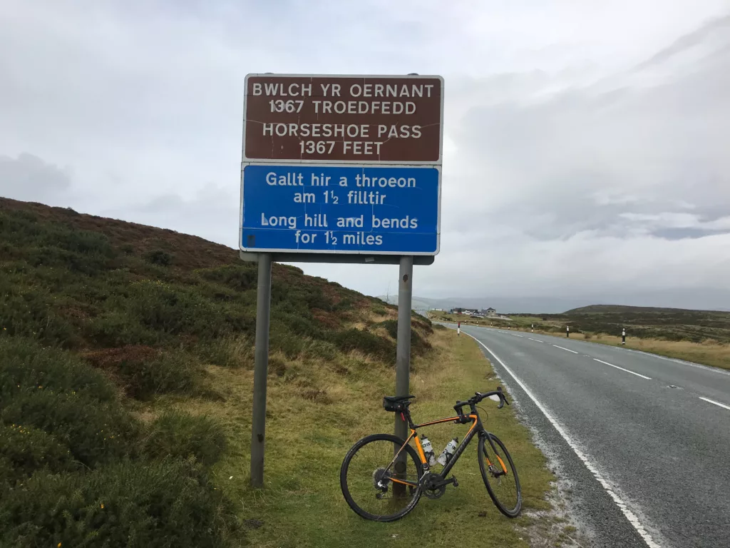
For the main southern ascent, allow roughly 6km of climbing at an average of around 5–6%, gaining approximately 300–330 metres. Exact figures vary with the start and finish used: a segment beginning on the lower approach is longer than the established hill-climb course beside the Britannia Inn. The pass reaches about 417 metres above sea level.
| Detail | Main Horseshoe Pass ascent |
|---|---|
| Location | North of Llangollen, Denbighshire |
| Road | A542, approaching from the Llangollen side |
| Climb distance | About 6km, depending on the segment |
| Average gradient | Approximately 5–6% |
| Elevation gain | Roughly 300–330m |
| Steeper pitches | Around 12% |
| Pass elevation | About 417m |
| Road character | Open to traffic, with exposed upper slopes |
The defining feature is a broad horseshoe-shaped sweep around the hillside, rather than a stack of tight Alpine hairpins. You can see another part of the road across the slope as you approach it. That changing direction matters on a bike: the wind that slows you on one stretch may help once you have rounded the bend.
How to pace the climb from Llangollen
Use the approach from Llangollen to warm up rather than treating the first rise as the start of a flat-out effort. The main road has steeper climbing around the wooded lower section, so select an easier gear before your cadence drops. Keeping that part controlled leaves more in reserve for the open road above.
Beyond the trees, the road opens onto the hillside and the gradient becomes more manageable, but exposure takes over as part of the challenge. Judge your effort by breathing or power rather than trying to maintain a fixed speed into the wind. The horseshoe bend changes your heading again, so resist the temptation to chase every brief increase in speed.
For a first visit, aim to reach the upper slopes still able to hold a steady rhythm. Our guide to riding short, steep climbs explains gear selection and the choice between sitting and standing on sharper ramps.
Horseshoe Pass hill climb and the Old Shoe
The main-road Horseshoe Pass hill climb uses the DHC/1 course, listed at 2.3 miles, or approximately 3.7km. It starts beside the Britannia Inn and finishes at the first lay-by on the left at the top of the pass. This shorter timed course explains why race descriptions give different distances from guides measuring the longer approach.
The Old Shoe is a separate challenge. It climbs from Pentredwr on a narrow lane towards the rear of the Ponderosa site, packing much more severe climbing into roughly 1.5km. Its cattle grid and steep gradient demand a different approach from the wider main road. If you download a route, check which ascent it uses before choosing your gearing.
The Old Shoe hosted the 2022 National Hill Climb Championships, where Andrew Feather and Illi Gardner won the senior titles. That championship was on the steep lane, not the main A542 horseshoe. For anyone trying hill-climb racing, the distinction is more useful than comparing times without checking the course.
Gearing, traffic and the descent
A road bike with a comfortable low gear is well suited to the main ascent. The average gradient does not justify arriving over-geared: the sharper pitches are easier to manage if you can change down and keep pedalling smoothly. Riders adding the Old Shoe should plan for a much steeper effort, especially with tired legs or luggage.
The A542 carries cars and motorcycles as well as cyclists. Its width does not make it traffic-free, and conditions can change between visits. Hold a predictable line, leave space around parked vehicles and choose a safe place off the carriageway if you want to stop for photographs.
Before descending, put on a layer if you have cooled down at the top. Keep your speed within your sightline through the bends and allow for gusts, wet patches, gravel and animals near the road. An easy climb in warm sunshine can still be followed by a cold, exposed descent.
Food stops and weather
Do not build your ride around a guaranteed stop at the Ponderosa Café. The long-established business closed in late 2024, and its closure was reported in 2025. Treat the site as a landmark and confirm any current refreshment provision before relying on it. Carry enough water and food for the climb and return, with Llangollen offering a more practical place to plan your main stop.
Check the forecast for the pass rather than assuming conditions will match those down in town. Wind, low cloud and winter ice can change the character of the ride. Follow any road closure notices, and choose a lower route when the upper slopes are unsuitable.
Building a North Wales riding trip
-
 Photo Credit: Cor Vos



Llangollen is a useful starting point for a standalone ascent and return. Add any extra distance deliberately rather than assuming that a short line on the map will be an easy extension: the surrounding lanes can add substantial climbing. Check the whole route profile, surfaces and junctions before setting off.
For a wider trip, our guide to cycling climbs in North Wales and Snowdonia offers other mountain-road options. If you also want a coastal ride on a separate day, Marine Drive around the Great Orme provides a shorter, rolling alternative from Llandudno.

